Are we planning a built environment that can withstand increased flooding from climate change? A recent study examining the increased risk of flood damage concluded that due to climate change, by 2050, the United States will see a 26% increase in the risk of flood damage. With each significant storm, the increased risk of flood damage to our homes, offices, and schools is clearer and more undeniable, yet adaptation lags. No one knows more about this than land use professionals. Their advice? Property development requires careful due diligence and trained professionals that can do a comprehensive review to help you successfully navigate site selection.
Deliberate decisions to develop on flood risk land is a growing concern in the densely populated areas of the northeast. In New Jersey, one study estimates that since 2009 housing is being developed nearly three times higher in the coastal flood-risk zones than in safer areas. That adds up to around 4,500 new homes being built, worth around $4.6 billion, in risk areas, even after Hurricane Sandy displayed the threat. In 2018, 12,350 new apartment buildings were being planned in flood zones in NYC. That amounts to about 1 in 8 new apartments deliberately being built in at risk areas in America’s most populated region.
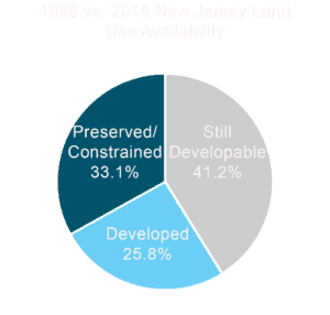
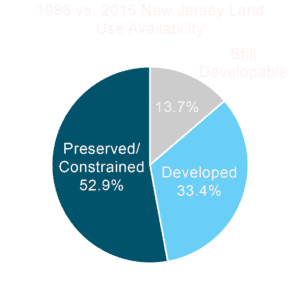
The northeast, of course, remains a desirable place to live and work. As densely populated as it is, however, any undeveloped land most likely comes with its fair share of environmental constraints.
The amount of developable land in population centers is limited and shrinking every year. Typically flood hazard areas discourage developers from building on flood prone properties, however, construction on at-risk areas is becoming more and more common as demand increases to meet the needs of population growth and land use becomes constrained.
Even if you are determined to build on land safe from flooding, the path to successfully doing so is not always clear. Flood zone maps are supposed to guide purchasers away from risks, but the US hasn’t invested nearly enough in flood mapping, and the maps we have are too often inaccurate. This means properties located outside of the flood zone identified on the flood zone maps may in reality be within a flood hazard area that is unmapped.
A 2020 report estimated only about 33% of rivers and streams and about 46% of shoreline in America have flood hazard information available. As for the flood maps we do have, they are frequently out of date. As of December 2016, 58% of FEMA’s maps did not meet their own standard of “New, Valid, or Updated Engineering (NVUE).” This means that as of 2016, more than half of the database required a re-study or had not yet been validated.
Advances in technology and updated flood studies are identifying larger flood hazard areas with increasing frequency. The main drivers of this increase include both the effects of climate change and expanded land development.
While building requirements in flood hazard areas aim to minimize any construction related impact on stormwater runoff and flooding, the process is not perfect. New development can sometimes contribute to unexpected effects on flooding downstream and to adjacent properties. The development factors that contribute to increased flooding include replacing vegetated areas with impervious surfaces, removal of wetlands, grading fill that results in a loss of flood storage area, and changes that redirect the flow of stormwater.
Climate change is also a major contributing factor to flood maps becoming inaccurate. A recent report indicates that flooding in New Jersey will increase significantly through higher intensity rainfall. This is a result of the atmosphere warming and holding around 7% more water, then releasing it. FEMA maps utilize models called Atlas 14, which only factors in historical data up to 1999. In other words, in some cases, we are getting a lot more rain than we did when the maps we use were created.
Both of these factors mean that properties that do not have a history of flooding or were not identified as at risk in the past, may be at a higher risk of flooding in the near future.
The idea of “managed retreat” is gaining some traction to solve the issue of developed flood risk land. The concept is to buy out properties in flood zones and preserve the area as open space. In New Jersey, for example, the Blue Acres program, which LAN has a history of working with, buys out flood zone property and preserves the land as open space while helping people move to higher ground. However, we may not be moving fast enough.
After Hurricane Ida caused massive flooding in the northeast in September of 2021, the NJDEP set out to revamp the Blue Acres program. The goal is to take a more proactive approach that includes anticipatory buyouts and the inclusion of stormwater resilience measures; however, current funding is far below the needed level. The Blue Acres Program is paid for by a combination of federal and state funding, but is seeking additional funding from all sources in hopes of managing the wetter future ahead.
The financial and community losses from floods are substantial. FEMA estimates 25 percent of small businesses never reopen after a disaster, and according to one study the US averages $32.1 billion in flood loses annually, a number projected to rise to $40.6 billion by 2050 using a current predictive model. To put that in perspective, that is a 26.4% increase in the cost of flood damage over the same time as a typical 30-year mortgage.
Flooding risk should definitely be calculated in phase one of a development project. To make a strategically sound decision, first you need a detailed understanding of the property’s current risk. A determination of a property’s flood hazard status is not merely reviewing existing FEMA flood maps; it involves determining the flood hazard area of unmapped waters on- and off-site. As part of the improvement planning process, a qualified land use specialist like those under our roof of services at LAN Associates, can perform a desktop review to evaluate available flood maps including those prepared by the State and Federal Emergency Management Agency, as well as review a site for unmapped waters which require a flood hazard area analysis. Doing this type of review early in the planning phases of any development can help anyone considering buying a property understand and mitigate their risk.
Secondly, you need to assess your future risk. The issue is evolving, and while there is consensus that the problem will continue to escalate, the severity and specific future impact on any given plot of land is much harder to pin down. The best advice is to work with a land use professional on establishing a plan that leaves your structure with a bit of a buffer. If your potential site is not in a flood zone, but is right on the edge, you may want to weigh potential risk against the long-term plan.
LAN Associates is a full-service architecture and engineering firm with an in-house team of land use professionals and civil engineers. Our land use team has decades of experience evaluating property development risks and obtaining the permits necessary to work within environmentally sensitive areas. LAN’s civil team provides site design and construction contract administration services and has dedicated specialists with experience in storm water management, flood hazard mitigation, erosion and sediment control plans, and wetland delineations. All of LAN’s teams serve a variety of commercial property managers, municipalities, boards of education, county, and state agencies, as well as ecclesiastical, higher education and senior living clients.
LAN Associates is a full-service engineering, planning, architecture, and surveying firm founded in 1965. We take pride in our ability to address the distinct needs of our large and varying client base.